
Technology
China NOA Hardware Stacks: How to Assess Sensors, Compute, Maps and Operating Limits
A practical framework for assessing China NOA hardware: sensor layouts, compute platforms, map dependence, software integration and real operating limits.
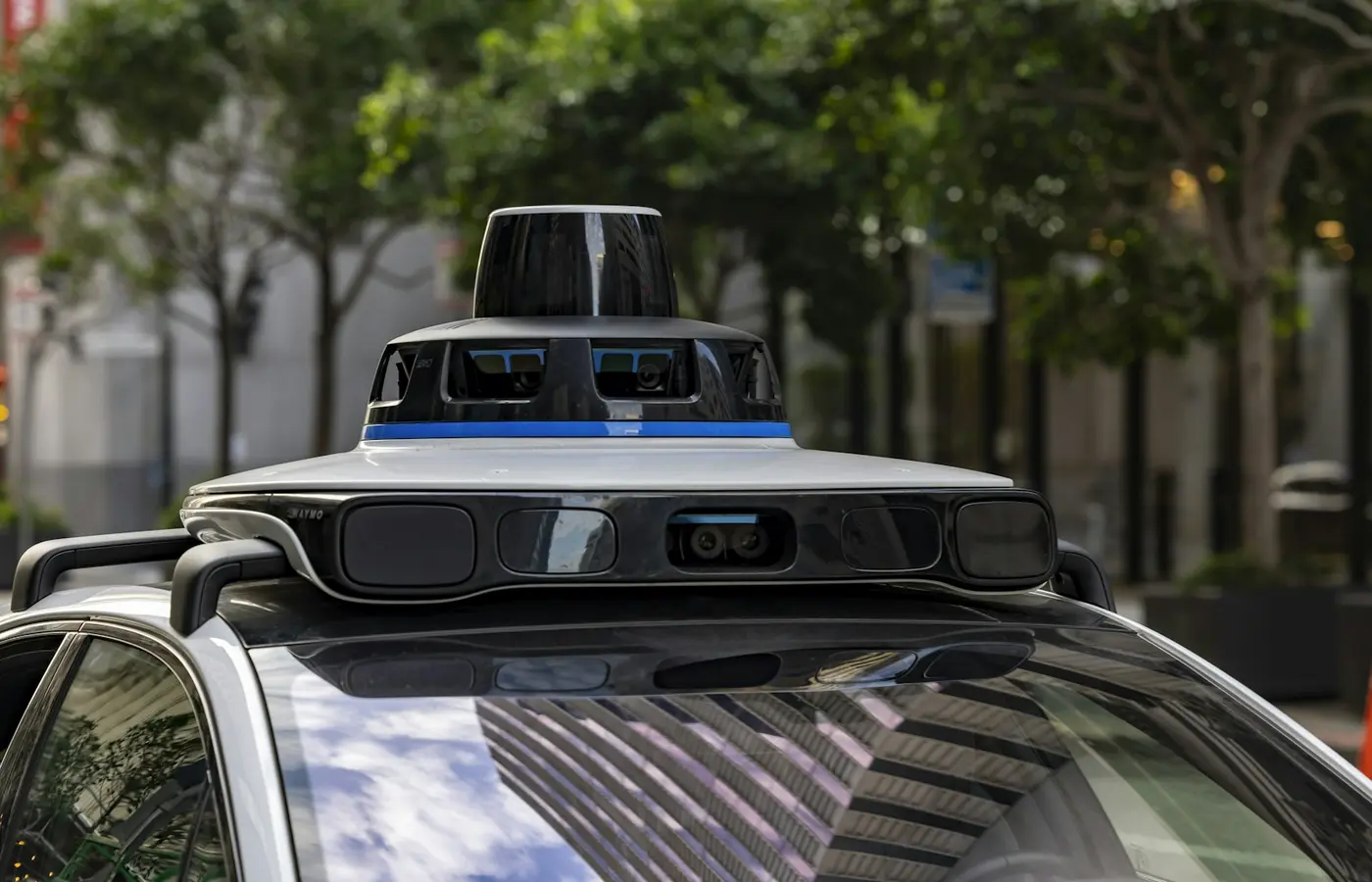
Navigation-assisted driving systems in Chinese vehicles are often marketed through a short list of headline specifications: lidar count, camera count, an AI-compute figure in TOPS, or terms such as “urban NOA” and “map-free.” Those details can be useful, but none is a complete measure of what a system can do.
For buyers, fleet operators and analysts, the more useful question is: what is the complete stack on this exact vehicle, and under what conditions is the function intended to operate? The answer depends on sensors, onboard computing, perception and planning software, navigation inputs, vehicle-control integration, driver monitoring and the documented operating domain.
This matters especially in China, where automakers can update assisted-driving functions rapidly through over-the-air releases, offer different capabilities by trim level, and use similar marketing labels for systems with substantially different hardware and software architectures. China’s NOA market also includes automaker-developed stacks, supplier-delivered systems and hybrid arrangements. As explained in China Vehicles’ overview of NOA development models, the boundary between an in-house and supplier-led system is rarely absolute: even automakers with their own software teams may source chips, sensors, middleware or engineering support externally.
What an NOA hardware stack includes—and what it does not prove
NOA, short for navigation-assisted driving or navigation-on-autopilot, generally describes a driver-assistance function that uses a planned route to support tasks such as lane following, lane changes, ramp transitions and some intersection or traffic-light scenarios. Exact naming varies by manufacturer. Highway NOA, urban NOA, city NOA, point-to-point navigation and parking-linked navigation are not standardized performance grades.
A complete NOA stack typically includes:
- Sensors, such as cameras, millimetre-wave radar, ultrasonic sensors and sometimes lidar.
- An assisted-driving domain controller, combining processors, memory, power management and safety-related hardware.
- Perception software, which interprets lanes, vehicles, road edges, traffic controls and other objects.
- Prediction, planning and control software, which selects a driving path and commands steering, braking and acceleration within vehicle limits.
- Positioning and navigation inputs, including route guidance, satellite positioning and one or more forms of road-network or map data.
- Driver-monitoring and warning functions, designed to verify that the driver remains available to supervise.
- Vehicle integration, including braking, steering, electronic architecture, diagnostics, fallback behaviour and software-update capability.
A specification list describes the intended ingredients, not a guaranteed outcome. A vehicle with lidar is not automatically more capable than one without it. A controller with a larger published compute number does not automatically deliver smoother planning or stronger safety margins. Equally, a system advertised for urban routes may be limited by weather, lane quality, road type, local activation rules or software version.
The authoritative document for a particular vehicle is normally its current owner manual, feature terms, in-car availability notice and official configuration material—not an old launch presentation or a demonstration video.
Sensors: assess coverage, redundancy and integration—not just the count
Sensor count is one of the easiest specifications to market and one of the easiest to misread. The relevant questions are where each sensor is located, what it is intended to detect, what overlaps exist between sensors, and how software combines their inputs.
Cameras
Cameras provide rich visual information. They can identify lane markings, traffic lights, signs, road users and many contextual cues that are difficult to express as simple distance measurements. A forward camera with a long focal length can help identify objects farther ahead, while wide-angle cameras can support close-range awareness and parking functions.
But camera performance can be affected by glare, darkness, rain, fog, dirty lenses, blocked views and weak lane markings. High resolution alone does not establish useful perception range, low-light performance or the quality of the models processing the images.
Millimetre-wave radar
Millimetre-wave radar is commonly used to estimate the range and relative speed of objects, particularly vehicles ahead. It can remain useful in conditions where optical sensors have reduced contrast, although it also has limitations in object classification and in interpreting complex roadside environments.
Radar configurations vary considerably. A published radar count does not reveal the field of view, signal-processing approach, mounting constraints or how aggressively the system relies on radar data in planning decisions.
Ultrasonic sensors
Ultrasonic sensors are generally most relevant at low speed and close range. They remain important for parking assistance and may support low-speed manoeuvring, but they should not be treated as evidence of highway or city-navigation capability.
Lidar
Lidar can provide detailed three-dimensional distance information and may help create robust geometry around nearby objects and road boundaries. Its value depends on its range, field of view, placement, cleaning strategy, weather tolerance, integration with other sensors and the software’s use of its data.
Lidar is therefore a design choice, not a universal requirement for urban NOA. Some Chinese systems use lidar; others use camera-led sensor fusion with radar. Neither architecture can be assessed fairly from component presence alone.
A dated example illustrates why context matters. The 2023 China Passenger Car Navigate on Autopilot Industry Report described the Jiyue 01’s then-announced configuration as including cameras, ultrasonic sensors, radar and dual Nvidia Orin-X processors, with a stated 508 TOPS of AI compute. That reported configuration is useful as a historical example of a multi-sensor design, but it should not be treated as current vehicle specification data without checking the manufacturer’s latest materials. The report is available here.
When comparing sensor layouts, look for these practical details:
- Forward, side and rear coverage rather than total sensor number.
- Whether the vehicle has sensor overlap in critical areas.
- Lidar placement and whether its view can be obstructed by dirt, ice or damage.
- Camera cleaning, heating or diagnostic provisions where disclosed.
- Owner-manual warnings about rain, fog, glare, low light, blocked sensors and road contamination.
- Whether parking sensors are being presented separately from higher-speed navigation functions.
Onboard computing: why TOPS is only a starting point
TOPS—trillions of operations per second—is frequently used to describe the theoretical AI-processing capacity of an automotive chip. It can indicate the class of compute hardware an automaker has selected, but it is not a direct score for NOA capability.
A compute figure does not answer several key questions: Which processor generation is installed? How much compute is available after other workloads? Which neural-network models run on the vehicle? How efficiently are sensor streams processed? How is heat managed? What redundancy exists for critical functions? How quickly can software be updated and validated?
The actual workload can be substantial. Multiple camera streams, radar data, lidar point clouds where fitted, localization inputs, occupancy models, trajectory prediction and planning all compete for computing resources. Manufacturers must also manage latency: a technically powerful controller is of little value if sensor data arrives late, vehicle-network communication is constrained or control commands are poorly integrated.
Thermal and power design are similarly important. An automotive domain controller must operate across wide ambient temperatures and under sustained load. Cooling, mounting, electrical architecture and fault handling all influence whether a system can maintain intended performance over time.
Functional safety architecture also deserves attention, though a marketing reference to a safety standard should not be taken as an overall proof of real-world system safety. Buyers should distinguish between a component-level claim, a system-level engineering process and the operational behaviour of the final vehicle.
For comparison, record the installed compute platform where officially disclosed, but avoid turning a TOPS figure into a ranking. A lower-numbered platform can support a well-scoped system effectively; a higher-numbered platform may be reserved for future features, multiple functions or more complex sensor processing.
Maps, navigation data and the real meaning of “map-free” NOA
“Map-free” is one of the least precise labels in China’s assisted-driving market. It usually does not mean that a vehicle operates without route information, positioning, road-network data or any form of stored geographic reference.
Instead, the term commonly signals reduced dependence on a traditional high-definition map for driving decisions. Older or more tightly geofenced systems may rely heavily on detailed map layers containing lane geometry and road attributes. Other approaches may use lighter map layers, ordinary navigation maps and stronger real-time perception. A perception-led approach can reduce reliance on prebuilt detailed road representations, but it still needs to understand the vehicle’s route and its location on the road network.
The practical questions are more specific:
- Does the system require a destination to activate navigation assistance?
- Does it rely on high-definition maps, lighter road data or standard navigation maps?
- Are functions available nationwide, only in named cities, or only on approved road types?
- What happens when the vehicle reaches newly built roads, construction zones or road layouts that differ from navigation data?
- Does feature availability depend on an internet connection, account activation or an active software subscription?
- Can the system continue safely if localization confidence falls or navigation data is unavailable?
Terms such as “no HD map” and “map-free” should therefore be read as architecture descriptions, not promises of unrestricted operation. Availability can also change through software updates, regional releases and manufacturer policy. A current owner manual or in-car activation screen is more useful than a broad launch claim.
System boundaries matter more than the NOA label
NOA remains driver assistance unless official documentation clearly states otherwise under applicable law. The driver’s responsibility to supervise, maintain control and intervene when needed is central to evaluating the system.
The operational design domain—the conditions under which the feature is designed to work—is more meaningful than a label such as urban or highway NOA. Before comparing vehicles, identify whether the manufacturer documents support for:
- Controlled-access highways, urban expressways, ordinary city roads or a combination.
- On-ramp and off-ramp navigation.
- Interchanges, merges, lane splits and toll-area approaches.
- Lane changes initiated by the system versus driver-confirmed lane changes.
- Traffic-light recognition and intersection handling.
- Pedestrian-rich streets, unprotected turns and mixed traffic.
- Navigation-linked parking or automated parking as a separate function.
- Road construction, temporary traffic management and unusual lane arrangements.
- Minimum and maximum speed conditions.
- Weather, low-visibility and sensor-obstruction limits.
- Connectivity, geofencing and location-specific feature restrictions.
China’s road environment makes these distinctions particularly important. Dense urban traffic may include frequent delivery vehicles, electric two-wheelers, changing curbside activity, temporary barriers and inconsistent lane markings. Highway conditions introduce other challenges, including complex interchanges, construction diversions and merging traffic. A demonstration on a selected route cannot establish reliable performance across these conditions.
Driver-monitoring requirements should be checked as carefully as sensor hardware. Review whether the system uses a driver-facing camera, steering-wheel interaction, visual prompts, audible alerts and escalation procedures. These safeguards are part of the product’s operating model, not peripheral features.
A practical comparison method for Chinese NOA systems
The most reliable comparison is made at vehicle-variant level. Do not compare brand-level claims when the hardware and feature set can change by trim, model year, production batch or software release.
Use the following template for each vehicle under consideration:
| Item | What to verify |
|---|---|
| Exact vehicle | Model year, trim, market and production period |
| Hardware | Camera, radar, ultrasonic and lidar layout; sensor locations where disclosed |
| Compute platform | Controller supplier, chip family and claimed compute figure, if officially published |
| Software stack | Automaker-led, supplier-led or jointly integrated system; latest stated version |
| Navigation inputs | Route requirement, map dependency, localization requirements and data connectivity |
| Operating domain | Highway, urban, parking-linked or other documented scenarios |
| Activation conditions | Account, subscription, optional package, region or road eligibility |
| Driver role | Monitoring method, hands-on prompts, takeover warnings and stated responsibility |
| Exclusions | Weather, poor markings, construction, tunnels, sensor blockage and other listed limits |
| Update history | Official OTA notices showing what changed and for which vehicles |
For fleet buyers, this process should also include service support, repairability of cameras and lidar units, calibration requirements after collision repair, data-connectivity costs and the manufacturer’s policy for feature changes after delivery.
For analysts, separate three categories in published comparisons: confirmed hardware, manufacturer-stated function scope, and independent evidence where available. That separation prevents a specification sheet from being misread as proof of safety, reliability or driving quality.
What to watch next
China’s NOA systems will continue to change faster than conventional vehicle product cycles. New controllers, lower-cost sensor packages, lighter map dependence and OTA-enabled feature expansion can all alter a vehicle’s capability after launch. The relevant version is therefore not simply the model name; it is the specific vehicle, installed hardware, market configuration and software release.
The key takeaway is straightforward: evaluate Chinese NOA as an integrated, supervised driver-assistance stack. Sensor counts and TOPS numbers are useful inputs. They are not conclusions. The decisive evidence is the vehicle’s documented operating domain, the conditions under which the feature can be used, and how the complete hardware and software system is integrated.
FAQ
Does more TOPS mean a Chinese NOA system is better?
No. TOPS is a measure of advertised AI-processing capacity, not a direct measure of perception quality, planning behaviour, reliability or safety. Software efficiency, sensor data quality, thermal design, vehicle integration and the system’s operating domain all affect the delivered result.
Is lidar necessary for urban NOA in China?
Not necessarily. Lidar can add useful three-dimensional sensing, but some systems use camera-led sensor fusion with radar instead. Whether lidar improves a particular product depends on its placement, field of view, software integration, maintenance provisions and the conditions in which the system is designed to operate.
What does map-free NOA actually mean?
Usually, it means reduced reliance on a conventional high-definition map rather than the absence of all geographic data. The vehicle may still require route guidance, positioning, ordinary navigation maps, road-network information and connectivity. Check the manufacturer’s current documentation for location and road-type restrictions.
How can I verify whether NOA is available on a specific Chinese vehicle trim?
Start with the current official configurator, vehicle specification sheet and owner manual for the intended market. Then check feature terms, in-car activation requirements and official OTA release notes. Confirm the exact trim, model year and software version, because availability can differ even within the same model line.